
LiDAR Corridor Survey
We recently completed a topographic survey to inform the design of a new sewer rising main in North East Victoria. 12P Consulting carried out the survey using a next generation LiDAR payload. The survey picked up the 2.1km corridor using a linear flight path in three consecutive 700m long bands of three passes each.
This type of survey provides the opportunity to obtain clearance heights of powerlines, heights of trees and even tree diameters, all after leaving site.
In this configuration, a detailed corridor width of over 100m was captured on the centreline with a further 80m of lower detail LiDAR points captured on either side which provided greater context beyond the survey scope area.
This new generation of LiDAR scan is capable of a total of 5 returns, meaning that even more detail of vegetation and better low vegetation penetration is possible, thereby getting a better representation of the ground in difficult to access areas. The survey was augmented by the acquisition of over 300 ground control points and check points which were used as a quality control measure to the LiDAR point cloud and to provide precise locations of buried services.
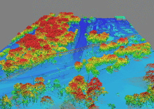
LiDAR point cloud - colourised, elevation and class modes
12P Consulting worked with a plumber to undertake non-destructive excavation of existing services and provide depth and location on the final completed drawings.
The final deliverables for the project included the classified LiDAR point cloud, a shaded digital elevation model (showing a relief map of the site), a 2.5cm resolution orthophoto - all bundled in an AutoCAD 3D drawing package.
The ability to effectively create a 3D digital twin of the site has allowed the designer who is not local, to access detailed site information for modelling and design purposes. Significantly more information can be captured in a fraction of the time of traditional site feature and level surveys.
A portion of the final AutoCAD output showing contours, linework, significant trees and other features


